Precision Forest Inventory Using Auxiliary Data Sources
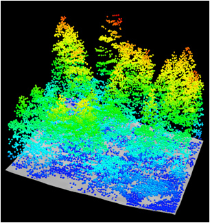
In this project, we are investigating the ability of auxiliary data sources to increase the precision of forest inventory estimates and mapped products on the Kenai Peninsula. Our interest specifically lies in the synergy between airborne scanning LiDAR and Landsat auxiliary data. We are exploring both parametric and non-parametric modeling approaches are being explored.
Our latest analysis examined a model-assisted approach to quantify the effects of different LiDAR pulse densities and different numbers of ground (correlation) plots. The results of the study will improve precision of medium to high-resolution mapped products.
This research is funded by the USDA Forest Service, PNW FIA, and conducted in collaboration with Dr. Hans Andersen.
Regression Estimators for Improving the Precision of Regional Forest Inventory Estimates
The Forest Inventory and Analysis (FIA) program of the Forest Service, U.S. Department of Agriculture (USDA) provides summaries about forest resources for selected geographic areas (e.g., county, state, region) and domains (e.g., forest type group, species group, size class) based on stratified estimation. In the first phase of the inventory, 76 strata in Oregon (OR) and 94 strata in Washington (WA)are derived based on survey units, ownership groups, and the forest type layer and canopy variables from the national land-cover database 2001 (NLCD). We are exploring regression estimation approaches using continuous auxiliary variables. Our goal is to simplify the current FIA estimation procedure by developing a model-assisted, regression-type estimator that does not require stratification but incorporates auxiliary information directly.
This research is funded by the USDA Forest Service, PNW FIA, and conducted in collaboration with Dr. Vicente Monleon.
Thematic and Spatial Accuracy of Imputed Biomass Estimates
In this project, we examine the accuracy of imputed forest biomass estimates on the Malheur National Forest (MNF) in eastern Oregon. Using forest inventory plot, Landsat, LiDAR, and climate data, we are comparing nearest neighbor imputation approaches and geographic weighted regression to estimate standing tree biomass on about 200,000 acres of the MNF. The results of our research will examine selected imputation and modeling methods for estimating and mapping biomass at varying scales.
This research is funded by the USDA Forest Service, PNW, and conducted in collaboration with Susan Hummel.
Riparian Function and Stream Temperature (RipStream)
The Oregon Department of Forestry (ODF) initiated the RipStream project in 2002 to assess whether current harvest regulations protected stream temperatures on private and State Forest land. This highly controlled study collected stream temperature, channel, and riparian vegetation data for two years pre-harvest and five years post-harvest at 33 sites in Oregon’s Coast Range. We are currently examining the effect of timber harvest on the magnitude and duration of stream temperature change as well as quantifying water quality rule compliance. The linear mixed-effects analyses incorporate a variety of data to model temperature change within and among sites. We communicate results to the Oregon Board of Forestry to inform their evaluation of current rule sufficiency.
This research is funded by ODF, EPA, the Oregon Department of Environmental Quality and the Headwater Research Cooperative, and is conducted in collaboration with Liz Dent and Dr. Lisa Madsen.